
TL/DR –
The remnants of Tropical Storm Ophelia could result in flooding rains in parts of the Northeast, while Tropical Storms Philippe and Rina move east of the Caribbean. Weather models predict anywhere from 1 to 8 inches of rainfall in parts of the Acela corridor and southern New England between Thursday night and early Saturday due to the moisture left in the wake of Ophelia. The 2023 Atlantic hurricane season has been notably busy, with 18 named storms so far, marking it as the third most on record.
Atlantic Hurricane Season’s Challenges Continue
Despite a brief pause, the Atlantic hurricane season is not over. Tropical Storm Ophelia’s remnants could lead to flooding in parts of the Northeast, while Tropical Storms Philippe and Rina loom east of the Caribbean.
Ophelia’s rain eased the D.C. area’s dryness, but drought remains in the west. In parts of the Acela corridor and southern New England, a challenging forecast emerges, predicting between 1 to 8 inches of rainfall as showers and thunderstorms roll in from Thursday night to early Saturday.
Tropical Storm Philippe poses additional challenges. Initially expected to approach Puerto Rico as a tropical depression, newer forecasts hint that it may veer east as Rina forms around it. As October approaches, known for notorious storm development near the U.S., meteorologists stay alert for sneaky, quick-forming storms in the Gulf of Mexico and Caribbean.
The Atlantic hurricane season has been notably busy. It marked the most packed Aug. 20-Sept. 28 on record, per tropical weather researcher Phil Klotzbach at Colorado State University. With 18 storms this year, it’s the third most to date.
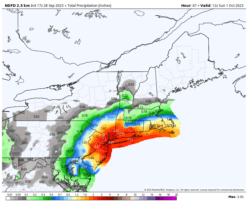
An Uncertain Forecast in the Northeast
The stubborn meteorological setup in the Northeast poses a “boom or bust” forecast for cities like Philadelphia, New York City, Hartford, and Albany. A corridor of intense downpours will likely establish into Friday night, with rains repeating over the same areas, potentially leading to isolated 6 inch totals.
Forecasting challenges stem from low pressure evolving from Ophelia’s remnants earlier in the week, causing cool, dreary conditions in the Mid-Atlantic and southern New England. Within this zone, an “inverted trough,” a concentrated area of low pressure, will form, causing heavy downpours. Pinpointing where a significant flood event may occur is challenging.
The stuck weather pattern keeps coasts unsettled and the middle warm and dry.
Tracking Philippe and Rina
Philippe, a disorganized storm east of the Lesser Antilles, shows 50 mph winds. Models suggest Philippe will head west before turning north, coming close to the northern Leeward Islands next week as a tropical storm.
Newly formed Rina, a 40 mph tropical storm east of Philippe, is expected to follow closely before turning more to the north, safely away from the islands. However, a potential “Fujiwhara” interaction between Philippe and Rina could push Rina farther west than initially forecast.
Read More Better Today US News
Comments are closed.